


The problems with planning your own Walk
A quick ‘Google’ will reveal many free walks and walking guides around Wiltshire, usually with a brief description and a sketched route map. These are excellent for the newcomer to gain experience, but are usually circular wanders around a village, or based on short well-used ‘dog-walkers’ routes. Fine for a quick 30 minute wander around a village or along the canal tow-path, but they don’t really provide the views and exhilaration of taking a real 4 - 8 mile walk that you have planned yourself.
With over 6,000 km of Rights of Way and nearly 67,000 acres of Access Land, Wiltshire provides some of the finest ‘easy rambling’ walks in the country - it just requires an up-to-date Map and a detailed plan to produce your own tailor-made walk. However, most people do not plan their walk in enough detail, and may not have sufficient knowledge of the area that they are visiting - particularly over details such as the location and status of ‘Permissive Paths’ and which footpaths are actually Rights of Way. This results, at best, a walk that does not meet their expectations, and at worst, a completely disastrous day. We hear tales in the Pubs and Hotels from walkers who have become hopelessly lost and taken a bus back to their B&B, where they ask for information about where they went wrong.
The solution......
Simply order a Self-Guided Walk Package from us. We start by taking your requirements, and produce a Route that covers the features that you require over a distance to suit you. At this stage we can then notify you of any possible problems, such as closed Rights of Way, back-road walking, or of difficult terrain such as overgrown paths or waterlogged areas.
Once we have been commissioned to produce a Self-Guided walk for you, we can then recommend any interesting detours in the area, notable Points of Interest (POIs), viewpoints, eating/resting places and accommodation, if required. If you are interested in Geocaching, then we can advise you of any Geocaches close to your route, or mark general areas in which they lie.
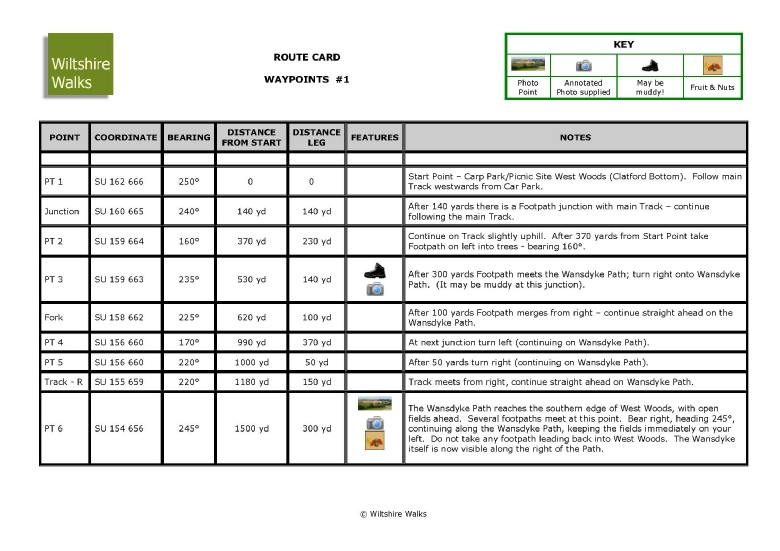
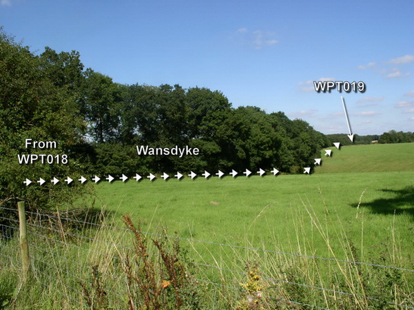
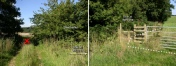
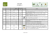
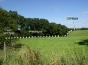
Your route is then planned in meticulous detail using information from our database that includes Gates/Stiles, POIs, Geocache locations, Ancient Sites, Sites of historical interest, and Vantage Points. The Route is formed from a series of Waypoints that can be later uploaded into a Handheld GPS unit if needed. The POIs can be added to the Route as extra Waypoints - POIs can include Ancient or Historic Sites, Sites of Scientific Interest, and any ‘Geocaches’ that may be in the area. The Route is then broken down into several smaller segments (typically one ‘leg’ per 2km or 1¼ mile) and Route Cards produced for each leg. Each document is then printed on A4 or Letter sized Bright White Paper. Optionally the paper may be waterproof or Bright White laminated. Each Route Card has associated Annotated Photographs, Drawings or Diagrams, so, when bound into a Folder, walkers can see both the Leg Route Card and a pictorial view simultaneously.
The Drawings and Route Cards, etc., are similar to those that we use on our own Guided Walks, but contain more detail than normal. They can show differing co-ordinate formats - e.g., Ordnance Survey National Grid for walking or NMEA WGS84 for use with GPS ‘Handhelds’.
Typically, our Route Packages will contain:
- A General Description of Walk – including any nearby Points of Interest (‘POI’s) and local Geocache information.
- A complete Route Drawing.
- The Route Cards – with Notes.
- Route Drawings and ‘To-Scale’ Map Drawings with Waypoints and Compass bearings (other coordinates may be requested).
- Detailed information for difficult sections.
- Annotated ‘To-Scale’ Map Drawings of the whole Route with POI and Waypoint Overlays.
- Annotated Photos of Route Legs with POI and Waypoint overlays.
- ‘Detours’ to POI’s, or Vantage Points, Pubs, Restaurants, etc.
- ‘What to do next’ on arrival (for linear walks).
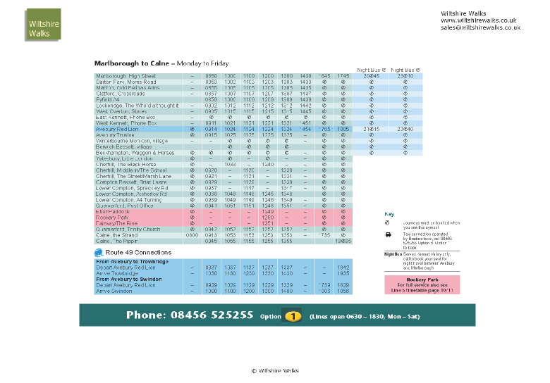
- Bus Timetables and Taxi telephone numbers.
- Hyperlinks and further reading.
- The Countryside Code.
- Route Cards in OS Grid Reference format - PDF.
- Route Cards in WGS84 NMEA format - PDF.
- Original Photos in PDF format.
- Annotated Photos in PDF format.
- GPX and other Positional Location files of Route, Waypoints and POIs.
- GPX and other Positional Location files of Detours.
Please use our Enquiry Form for more details.


Hover your Mouse over any image to reveal a larger version

| Avebury |
| Kennet Valley |
| Martinsell |
| Marlborough |
| Savernake |
| Villages |
| West Woods |
| Custom Walks |
| Self-Guided Walks |
| Map & Compass |
| Ley Line Dowsing |
| Ancient Trees |
| Walking for Beginners |
| Beginners Backpacking |
| Geocaching |
| Corporate |
| Activities |
| Activities |
| Corporate |