


How it all Started
Finally - thank you for visiting this Site; I hope that you will find something of interest here. The Site is heavily ‘under construction’, please accept my apologies over this - I have had to learn about Web Site design pretty much from scratch, and I realise that it isn’t particularly ‘pretty’ - but I hope to rectify that as soon as I can.
Please return frequently, as I am working my hardest to achieve a Site that has something for everyone. Please feel free to email me with any suggestions, broken links etc., if you would like further information about anything on the Site, or if you would like a Custom Walk prepared for you.
Peter Knight
Wiltshire Walks
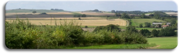
I suppose that the Wiltshire Walks started at several different points in my life; the initial seeds were sown when I first encountered an Ordnance Survey map and began to understand the significance, detail and accuracy of what I could see. Two years later, and geography lessons at school - using that same map, the OS 1” to 1 mile “Swindon and Devizes” map to learn about contours, magnetic variation, footpaths, distance measurement and walking time estimation, et al - I was hooked.........
Scouts followed next, and my first planned trek - for the “Hikers” badge, I think it was. To Avebury from Marlborough, over the Downs, (been there, done that), down West Kennet Avenue to the ancient sites: the Sanctuary, West Kennet Long Barrow, East Kennet Long Barrow (on private property then, as it still is now), “Little Avebury” - the Langdean Stone Circle - now curiously missing from the Explorer 157 map - more details here. Pushing on southwards to the magnificent views southwards from Adam’s Grave and Milk Hill (the highest point in Wiltshire nearby at around 968 ft); at the time I didn’t realise that I was following what is now the ‘new’ extended section of the Ridgeway, even though the map clearly states “Ridge Way”........ From here down the hillside to Stanton St. Bernard and camp-up close to the Kennet and Avon Canal. The following day involved an easy stretch along the canal towpath, Honeystreet, Wilcot, Pewsey, lunch at Pewsey Wharf, and then past Wootton Rivers and up into Savernake Forest for a second night’s camping. Day three was spent wandering through the forest, fishing the Carp Ponds, sunbathing and watching the wildlife - and especially remembering that the number of the new Grey Squirrels were equalling the number of our native Red Squirrels. I really regret not having a camera in those days....... An easy hike back through the Forest brought me down into Marlborough for a bath and a real meal!
That map never left my side - from then on it accompanied me on all sorts of expeditions, along the Kennet Valley, through Savernake Forest out to the southern villages, tracing the old Roman roads through the area, and what is still a Bank Holiday ‘pilgrimage’ for the locals - the walk across the Downs on the ‘Herepath’ out to Avebury and back, a round trip of about 13 miles.
A long gap ensued after leaving school and starting work; I worked long hours often involving nights and weekends, and as much of this took me out into the countryside, I had no need for planned walks or expeditions. I would accompany scouting friends on the occasional wander up through mid-Wales to Plynlimon and sometimes Snowdon, always carrying huge rucksacks filled heavy tents, massive sleeping bags and greasy cooking utensils. It wasn’t as much fun for me as walking lightweight carrying a makeshift tent (a piece of plastic 8ft x 8ft and some pieces of string), and I always remember my feet, soaking wet and cold, from walking through the peaty areas of mid-Wales in hob-nailed boots.
Illness struck next, and I was unable to work for 6 months or so. The summer was warm, and I started walking for fun again. I was surprised to discover that during my previous 5 years of walking inactivity how much clothing and camping equipment had changed. Lightweight and waterproof breathable fabrics were available, even for boots, and one or two-man tents could weigh as little as 2 lbs. I was hooked again, and began learning new backpacking skills, including how to cook properly!
After a few years of lightweight backpacking I found that again I was missing just ‘social walking’ - day walks with others in unexplored areas, finding new Rights of Way (RoW’s), and combining walks with other activities, such as photography, dowsing, tree identification, autumn fruit and nut collection, and of course, visits to the village pubs!
You may have realised that I am a ‘local’. I was born in the village of Manton, in a ‘prefab’ in Manton Close, just over a mile from Marlborough, yet still within the town boundaries. At the age of three I was walking up Manton Drove with my mother to collect nuts - “Hazel Drive” which mother called it, which still exists, and is part of several of the Wiltshire Walks that you will find on this Site. Friday morning we would walk the mile-and-a-half into Marlborough for shopping and then back again, and I remember my mother telling me that she would not push me in the wheelchair. The walk back seemed to take forever, and I remember asking to stop and look at the horses at Manton Grange, which was just an excuse to rest my tired little legs! I was educated in the town, and left town after school, yet I have returned back to Marlborough nine times, the last in 2001, which should be the last move back.
Wiltshire Walks was ‘envisioned’ three years ago, after a Marlborough College Summer School. During that Summer School I had been providing impromptu tours of the College and the Kennet Valley, and been giving evening ‘bat detection’ courses. Everyone seemed to enjoy these (probably because they were an unexpected ‘freebie’), and I could see that not only was this a business opportunity, but that it was something that was very obviously missing in the area. During the following two years I met several ex Summer School ‘students’ out walking the area, each who complained to me about of lack of information on local tours and walks, and that there were no guided walks available that were similar to those that I had provided at Summer School. So, last Autumn, I started the business plan in earnest, and put the wheels into motion in February of this year.
Two years ago Wiltshire County Council (now a unitary authority - “Wiltshire Council”) produced a document called “The Rights of Way Improvement Plan for Wiltshire 2008 - 2012”. This has since been followed up with an appendix which gives detailed results of surveys with users of RoW’s carried out across Wiltshire. These results make interesting reading - 28% or respondents (total 1042) saying that they preferred river walking, 26% forests, 18% downland, 17% open downland, the remaining 10% preferring walking on farmland. The most popular reasons for walking (excluding for health and exercise) were - wildlife (15%) and historic and ancient monuments (12%), whilst the most common complaints were the lack of signs and worries about becoming lost (26%), and obstructions and rutted paths (22%) with a further 12% saying that they didn’t walk because of lack of company during a walk, or of needing a guided walk.
I think these last figures justify Wiltshire Walks and what we are hoping to achieve!
| Avebury |
| Kennet Valley |
| Martinsell |
| Marlborough |
| Savernake |
| Villages |
| West Woods |
| Custom Walks |
| Self-Guided Walks |
| Map & Compass |
| Ley Line Dowsing |
| Ancient Trees |
| Walking for Beginners |
| Beginners Backpacking |
| Geocaching |
| Corporate |
| Activities |
| Corporate |